Monday, November 18, 2019

Hoover Dam and Lake Mead


Hoover Dam, originally Boulder Dam, was constructed between 1931 and 1935.  Thousands of depression-era workers found jobs there. Many lost their lives.

This large concrete, arch-gravity dam is located in the Black Canyon of the Colorado River, between Nevada and Arizona. Powerful generators use water flow to produce electricity.  Lake Mead formed as a result of the dam. It is one of the largest reservoirs in the US, supplying water to western states, and providing a water-sports recreation area.

When we last visited 30+ years ago, the top of the dam was highway 93 across the river.   We stopped there to look at the dam over the edge of the railing...Now the landscape around the dam has changed.

 A new bridge completed in 2010 crosses the river downstream from the dam; viewing platforms, walkways, and observation areas line the top of the dam. Multiple parking areas are connected to the walkways. Tours are available.

Saturday, November 16, 2019

Death Valley: Racetrack Playa

The mysterious sliding rocks of Racetrack Playa were one feature we were unable to see while in Death Valley National Park.  The Racetrack, a dried lakebed nestled in the mountains, contains boulders that leave tracks in the mud, indicating that they have wiggled, jiggled, slipped and slid across a perfectly flat area. These "sliding stones" have been studied by scientists, but no one has actually seen them move.  Recent observations using GPS and time-lapse photography have started to show some insight as to how the boulders move.

To get to this area one must drive 27 miles on an unpaved rocky dirt road. High-clearance vehicles with heavy-duty tires are recommended. And check with a park ranger for road conditions!

Death Valley: Mesquite Flat Dunes

Located near the village of Stovepipe Wells, Mesquite Flat Dunes area contains acres of white sand dunes, some as tall as 150 feet.
Sand that forms these dunes originates in the Cottonwood Mountains just north of the dunes field. Quartz and feldspar rocks are broken by erosion, and eventually become sand sized pieces.  Winds cause the sand to blow into ever changing piles.

 This area can be explored on foot, after parking in one of the access points along the way.


"Devil's Cornfield" is the name given these unusual looking formations that occur as sand dunes form around the mesquite plants that dot the area.

Death Valley: Furnace Creek Area

A variety of sights exist within the Furnace Creek Area of Death Valley National Park.  All the following are accessible by car, and fairly easy walks from parking to observation areas. A Visitor Center and Museum are located at Furnace Creek.


Artist's Drive exposes mineral deposits in a palette of colors in the volcanic formed rocks.  Pullouts are available for short term parking and photos.


Badwater Basin allows visitors a chance to stroll through the basin of an ancient lake.  What remains are layers of salt deposits.  At 282 feet below sea level, it is the lowest point in North America.


Dante's View, an observation area more than 5000 feet above sea level, allows one to view the expanse of Death Valley.  From high above it is easy to see the distinct valley between ranges of steep mountains. Access is via a steep, winding hard surface road. The last 1/4 mile is a 15% grade!


Zabriskie Point may be one of the most popular lookouts. A short uphill climb from the parking lot allows one to see a panoramic view of golden brown mudstone hills etched with gullies from the occasional intense rainfalls this area experiences.


Harmony Borax Works

Harmony Borax Works is one of the historic sites located with Death Valley National Park.  Borax was found in the hills by prospectors in 1881.  This processing plant operated from 1883 to 1888.  Forty workers produced 3 tons of borax daily.  Ten teams of 2 mules (the famed 20-mule teams) pulled the loaded wagons 165 miles to the nearest railroad town.  It took about 30 days to complete a round trip.  This site has rusty remains of buildings, machinery, and tanks used for processing the borax.
Informational signs explain the site; a museum is located at Furnace Creek Ranch.

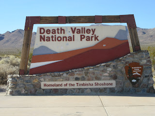
Death Valley National Park

Death Valley National Park is the largest national park outside of Alaska. The land started as a National Monument in 1933 then gained National Park designation in 1994. With over 3 million acres of wilderness, a diversity of scenery is there to explore.  Rocky peaks, twisted slot canyons, shifting sand dunes, and the below sea level salt flats are only some examples.  There are historic sites, hiking trails, visitor centers, lodging and camping.  Death Valley National Park is also a designated Dark Sky Park, for night sky viewing enthusiasts.  The park is open all year, but with summer temperatures frequently reaching 120 F or higher, the months of November to April provide more comfortable visiting conditions. 

Thursday, November 14, 2019

Reno/Lake Tahoe

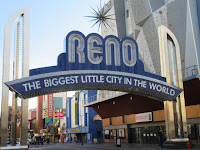
One day we drove through Reno, Nevada, then on to Lake Tahoe. Guide books stated Reno is the second most populated place in Nevada. University of Nevada, Reno occupies one section of the city. National Automobile Museum offers a chance to see vintage cars. And there are casinos for entertainment.


Lake Tahoe area in the Sierra Nevada Mountains is known for winter sking and summer water activities.  We observed kayaks and fishing boats on the lake. We drove a winding mountain road to Mt. Rose Ski Area, elevation 8260 feet, and saw some snow...

Sundial Bridge

Sundial Bridge crosses the Sacramento River in Redding, California.  Opened in 2004, this glass decked suspension bridge spans 708 feet across the river. 

Redding's Civic Auditorium and Turtle Bay Exploration Park are nearby.  Walking and biking trails along the riverfront, botanical gardens, an arboretum, and natural history museum are linked by the bridge.

Wednesday, October 30, 2019

Avenue of the Giants

Scenic "Avenue of the Giants" is 31 miles of winding country highway that parallels hwy 101 between Pepperwood and Phillipsville, CA. Much of the route follows the Eel River, and enters Humboldt Redwoods State Park, home to over 50,000 acres of tall ancient coastal redwoods and Douglas-firs.  


A Visitor Center with historical displays and interpretive kiosks is about half way into the drive.

Other attractions along the route include Shrine Drive Thru Tree, The Immortal Tree, The Eternal Tree, and Chimney Tree.  Hiking trails, horseback riding camps, camping facilities, lodging, shops and restaurants are also available.

Sunday, October 27, 2019

Prairie Creek Redwoods State Park


From our camp in Trinidad, CA we drove north to Kuchel Visitor Center near Orick.  After a short film, the park ranger pointed us toward Newton B. Drury Scenic Parkway and a drive through Prairie Creek Redwoods State Park.

This alternative to hwy 101 was definitely worthwhile. We found the 10 mile side trip to be yet another beautiful drive twisting and turning through giant trees.


A wayside sign with an arrow pointing to "Big Tree" encouraged us to stop. We walked a short trail, and there it was...the biggest redwood we had seen so far!


The information sign nearby stated it was 286 ft tall, 24 ft in diameter, and 75 ft in circumference. These two photos show the bottom and top of this giant.


This state park has many hiking trails that lead off into the forest.  One of the more difficult trails leads to Fern Canyon, a site used for filming parts of "Jurassic Park".


Tour Thru Tree


Located on the outskirts of Klamath village is Tour Thru Tree.  A 700 year old tree has been carefully carved out to allow most vehicles to pass through.  The tree still remains alive. Tourists have been visiting this site for years.

We did it just because...


Note: there are no drive-through redwood trees within the Redwood National and State Parks system.

Trees of Mystery

Located on hwy 101 near Klamath is Trees of Mystery.  A tourist stop since the 1940's, this unique place offers several trails among the coastal redwoods forest.


The Kingdom of Trees trail highlights colossal redwoods, sitka spruce, & douglas fir, while walking along the forest floor. Informational signs provide a self-guided tour of various areas, and unique plant growth within the forest.


 Skytrail, a gondola ride, carries one up into the forest canopy, stopping at a large observation deck that offers views of the forests, mountains, and the ocean. One can either ride the gondola back down, or walk down following the challenging Wilderness trail.


Trail of Tall Tales is a series of redwood chainsaw carvings devoted to the folklore of lumberman Paul Bunyan and Babe, the Blue Ox.

End of the Trail Museum has extensive displays of Native American artifacts, with many interpretive areas. And, there's a gift shop for souvenirs...

Klamath River Overlook

 Klamath, a small village at the end of the Klamath River, was once a booming salmon & steelhead fishing town. In 1926,  Douglas Memorial Bridge was built across the river, and connected the town to the Redwood Highway.  Two devastating floods, one in 1955, the other in 1964, literally washed the town down river and into the ocean.  The hearty survivors rebuilt the town each time. What was left of the bridge is now a viewpoint along the river.  

Further along Klamath Beach Road one arrives at Flint Ridge Overlook.  From there you can see where the Klamath River meets the Pacific Ocean, with a sand bar between. From the overlook we could hear the barking of sealions or seals that lounge on the sand.


Tourism is important today with fishing and jet boat river tours available. Hiking trails are abundant along the river and coast.

Jedediah Smith Redwoods State Park


East of Crescent City, US Hwy 199 takes one on a drive that winds through Jedediah Smith Redwoods State Park with its thick stands of old growth redwoods.  These trees are giants, and right along the highway!

Stout Grove, a section of the forest accessible only by trail, contains trees 300 feet tall surrounded by waist high ferns.  Other hiking trails are abundant in this park.

Smith River Scenic Drive turns off hwy 199 through a covered bridge and follows the Smith River.

Redwood National and State Parks


Established in 1968,  Redwood National and State Parks system protects a string of forests, beaches, and grasslands along the northern California coast. From the early 1900's to 1960 logging operations consumed a large percentage of original old-growth coastal redwoods. Redwoods National and State Parks joint effort was to protect and preserve the remaining trees. Some 40,000 acres of old growth, and 80,000 acres of second growth forests (those growing on previously clear-cut land) are now within the Parks system protection.


Coastal redwoods grow best here partly because of the mist and fog that moves in from the ocean and blankets the forest in a cloud.  Trees absorb lots of their moisture requirements from the fog.

Park Visitor Centers provide forest information, book campsites, and register hikers for backcountry camping. Campsites are varied, from full service with electricity and water, to those with only nature around you.  Trails are also varied...some handicap accessible, some easy and not too long, some difficult and long.  Besides walking, some trails are used for biking and/or horseback riding.

Tsunami and Earthquake Country

In 1964 a great earthquake in Alaska triggered a tsunami that destroyed Crescent City's business district.

Along hwy 101 , these blue & white signs indicate risky and safe tsunami areas, as well as evacuation routes inland and uphill from the coast.

Battery Point Lighthouse, Crescent City, CA

Built in 1856, historic Battery Point Lighthouse sits on a small island 100 feet offshore.    It is accessible only by foot and only at low tide.  Tide charts are posted. Guided tours of the lighthouse and museum are available.

Del Norte County California

On October 18 we drove from Oregon into California on hwy 101.  Crescent City, the most sizable town in Del Norte County would be our base right in the heart of Redwood country.   Within easy driving distance by car were Del Norte Coast Redwoods State Park and Jedediah Smith Redwoods State Park. 


Crescent City had lodging & restaurants,  history museums, interpretive displays in city parks, a marine mammal rescue center, Ocean World Aquarium, and some fantastic rugged coastal scenery.  Redwood National Park Headquarters and Visitor Center is located there.

Thursday, October 24, 2019

Oregon Highway 101: Brookings


Our final camp site in Brookings, OR was within walking distance of the marina. Nearby the Chetco River meets the ocean. Harris Beach State Park was a short drive away. 

 We could hear ocean waves and sea gull cries...

just a few miles south on hwy 101 we entered California.

Oregon Highway 101: Samuel H Boardman State Scenic Corridor

Samuel Boardman State Park, a long narrow park consisting of about 12 miles of rugged coastline and pocket beaches, is located along hwy 101 between Gold Beach and Brookings.  Viewpoint waysides offer access to several named coastal features:

Arch Rock and Natural Bridges


Whalehead, and Thomas Creek Bridge.


Built in 1961, is the highest bridge in Oregon, crossing 345 feet above creek bottom.

Oregon Highway 101: Cranberry Bogs

Cranberry bogs are visible from hwy 101 near Bandon, the "Cranberry Capitol of Oregon".  We stopped at one bog and were lucky to be able to talk with the farmer who was starting the harvest:
He explained that Oregon is second to Wisconsin for cranberry production.  His crop was ready for harvest...first step was to flood the field with water.  The machine he was steering through the field was cutting the berries from the plants.  Once cut, the berries float on top of the water.  A rope boom corrals the berries so they can be pulled to one end of the bog.  Loading into trucks involves an elevator-type machine.  Trucks carry the berries to a sorting facility: sorted by color, size, etc. From there they are processed into a final product such as juice, raw whole berries, or dried fruits.
Plants are left in the bog to regrow and produce more berries next season...

Oregon Highway 101: Face Rock


Near Bandon is Face Rock State Park, a day use state park with beach access and trails.  The main attraction, as observed from the viewing platform, is Face Rock.


Oregon Highway 101: Bandon


Bandon, rebuilt after a 1936 fire destroyed the entire business district, and many homes, sits on the Coquille River.  The Coquille River lighthouse served as shelter for residents during the fire.  No longer operational, it has the distinction of being the only lighthouse on the Oregon coast that is decorated with holiday lights in December.


We had lunch at a small crab shack near the pier.  After lunch we browsed the Farmers Market and some shops in the Old Town district.  

One shop of interest was "Washed Ashore" a community art project using salvaged marine debris to create art...I liked the turtle. 


In Bandon we also watched people "crabbing" from the pier...crab pots baited with fish heads or chicken are dropped in the water. After 20-30 minutes the pot is pulled out. Crabs of the correct size can be kept; smaller ones are returned to the water.

Oregon Highway 101: Cape Arago Scenic Loop


Our drive on Cape Arago Scenic Loop (Oregon highway 540) began in downtown North Bend.  This loop highway leads to Charleston, a quaint fishing village, and ends at Cape Arago State Park.  We stopped along the loop to see Shore Acres and Simpson Reef.

Shore Acres was the home of timber baron Louis Simpson; a huge mansion and beautiful botanical gardens florished, until fires destroyed the mansion.  The gardens remain, along with a caretaker's cottage (now gift shop).  More amazing are the unusual rock formations found along the shore. Formed by sediment, underground upheaval, and action of the waves over time the rocks themselves looked like a garden.


 Simpson Reef, part of Oregon Islands National Wildlife Refuge, is home to a large number of sea lions and seals.  The "barking" could be heard even before seeing the reef.

The loop dead-ends shortly after the reef.  We returned to highway 101 via Seven Devils Road, an equally scenic drive.

Oregon Highway 101: North Bend/ Coos Bay


A drive across Conde McCullough Memorial Bridge led into North Bend.  At the time this bridge was built in 1936 it was the longest (5,305 feet) bridge along the coast.  It rises high over the water for easy boat traffic clearance.

Coos Bay, close neighbor to North Bend, is the largest city  on the Oregon coast. History and art museums, theater, antique & gift shops, lodging and dining are abundant. 

Oregon Highway 101: Winchester Bay


Lunch one day was at a small crab shack on the pier in Winchester Bay, a fishing village near the mouth of the Umpqua River.


Close by was Umpqua River Lighthouse.  It is unique in that it is the only lighthouse on the Oregon coast that emits both red and white light.


Near the lighthouse was a whale watch viewing platform; we saw none! This Steller's jay came to see if we had any handouts...


In a protected area close to shore one could see rows of cage-like devices
used for aquafarming of clams, oysters, etc.


Tuesday, October 22, 2019

Oregon Coast Journey Begins


Touring the Oregon coast by traveling highway 101 was planned. We would set up camp, then use the car for sightseeing trips. On October 10 we left Eugene, headed west to Florence and started our journey south.


At Reedsport we followed the Umpqua River several miles east to  Dean Creek Elk Viewing Area. The river drive along hwy 38 was scenic with tall trees, steep rocky cliffs, and a highway with lots of twists and turns. We were able to see some of the Roosevelt elk scattered along the river flats.  Ducks, geese, and other birds also use this area as a rest stop on their migrations.

Oregon Dunes National Recreation Area Visitor Center is also located at Reedsport.  The dunes extend for miles along the coast.

Our first camp was at Lakeside, a small town on Tenmile Lakes.  In the 1930's Lakeside was a resort town favored by Hollywood stars.  Now it is a popular fishing spot.