After our first night at Leech Lake campground we planned a day of sightseeing. We left the park by car and traveled north from Federal Dam, MN to Highway 2. On our way west to County Road 39 another photo op appeared: The Big Fish Supper Club. They advertise "we will cook your fish"; did I mention we are in serious fishing country?
Traveling north on County Road 39 we drove through Chippewa National Forest on our way to Blackduck, MN. We stopped for gas along the way and inquired about interesting places to visit...just a ways north was Rabideau CCC Camp.
In the 1930's, after the Depression, Franklin Roosevelt established the Civilian Conservation Corp (CCC) to provide jobs and work skill training for young men ages 16-25. The men stayed in camps like Rabideau; they built bridges, roads, and campgrounds, planted trees, established firetowers and fought forest fires. Some earned high school diplomas if they attended classes held at the camp. Barracks for sleeping, a mess hall, hospital and dental clinic, tool shop and more were part of each camp. Workers earned $5 per month and $25 per month was sent to their family. By 1941 the CCC program ended. Of the 2600+ CCC camps started in the United States, the camp at Rabideau is one of three that has been preserved. Fifteen of the original 25 buildings are restored; they were placed on the National Register of Historic Places in 1976.
After our self-guided tour at the CCC camp we continued into Blackduck for lunch at a local cafe. On the entrance to town, in the park, was another statue...a large black duck...we had to stop!
Then it was on the road again, south toward Cass Lake, then into Walker for some shopping and back to the campground. Fall color was more noticeable here, with vivid red's, yellow, orange, and gold leaves among the green pines...
The next morning we were on our way toward home. We followed Highway 65, a familiar route from our days going back and forth to the cabin. Many old landmarks still existed!
Monday, September 22, 2014
Leech Lake Recreation Area
After two days we broke camp at Maplewood State Park and headed northeast... At lunch time we were in Park Rapids, and stopped at the Tourist Information/DNR parking lot for a break. What did we see but another large icon of Minnesota...a loon, complete with baby on her back. A photo was definitely in order...
From Park Rapids we drove toward Leech Lake. Located in the Chippewa National Forest, Leech Lake has 316 miles of shoreline. It is the third largest lake in Minnesota. Our destination: U.S. Army Corp of Engineers Park at Leech Lake. We would be camping there the next two nights.
Corp of Engineers manages the dam located on Leech Lake River at the outlet of Leech Lake. It was originally constructed in 1882 as part of the Headwaters reservoir system...designed to feed water to the Mississippi River and keep river levels high enough for use by logging and milling industries, and for an alternative to traveling by rail. The wooden dam was reinforced with concrete abutments in the early 1900's. In the 1970's the Corp's mission of regulating river levels switched from logging and river travel to recreation. The surrounding recreation area offers opportunity for camping and fishing. Most sites in the campground were occupied by some serious fishermen...
Once we arrived, we drove around the park and picked a site nestled in the hardwoods and pines...
Sunday, September 21, 2014
Otter Tail Scenic Byway
We left Maplewood State Park for a day of sightseeing, and followed the Otter Tail Scenic Byway through a number of small towns in the area. First stop was Pelican Rapids, and a trip to the local park to see "The Worlds Largest Pelican". Built in 1957, at 15 1/2 feet tall, he stands next to Mill Pond Dam where the Pelican River flows through town. One unusual fact about the Pelican River is that it flows north...
Next stop was lunch in Detroit Lakes, MN. Along the way into town we passed the site of WeFest. WeFest is one of the largest outdoor country music & camping events in the nation. Held at Soo Pass Ranch, visitors can camp and be entertained at one site; shuttle service takes visitors to downtown locations as needed. The entire three day event attracts thousands of fans every summer.
From Detroit Lakes, we stopped in Frazee, MN. Signs along the highway told to stop and see "Big Tom", the worlds largest turkey gobbler statue in the world! At 22 feet tall, Big Tom sits at the entrance to the local public park. Tom has been a fixture in Frazee since 1986, being replaced in 1998 when the original Tom burned to the ground in a renovation blowtorch accident. Large turkey farms located nearby explain the significance of Tom to the community.
Our last stop before returning to the state park was the town of Perham, MN. Tuffy's Dog Food and Barrel O'Fun snacks are two large industries in this small town. We also located the homeplace where our neighbor grew up years ago...
From Perham, it was back to the park to relax and enjoy a crackling campfire...
Maplewood State Park
Maplewood State Park, located 7 miles east of Pelican Rapids, MN on State Highway 108, was our home for the first two nights of a week long RV trip to do some "leaf color watching" in northern Minnesota.
This State Park, established in 1963, is a recreational area of about 9000 acres. It is located in a geological transition area between the state's eastern forests and western prairies. The hills (some up to 1600 feet elevation) within are covered with hardwood trees: sugar maple, basswood, elm, and aspen. Occasional red cedars and tamarack are also found. Lakes included within the park include Lake Lida (the largest), Beers Lake, Grass Lake, Bass Lake, Field Lake, and many smaller ones.
Our campsite was next to the shores of Grass Lake. Fishing, hiking, horseback riding, swimming, and camping are summer activities. In winter, trails are used for skiing and snowmobiles.
Fall color was just starting to appear in the maples...
Tuesday, August 19, 2014
"Up North" Minnesota
On our first RV trip since returning to Minnesota, we headed "Up North" to Two Harbors, MN. We had reservations at Burlington Bay Campground, located on the shores of Lake Superior, for a rally with members of the RV club... We arrived on Thursday afternoon (August 7th) and stayed until Sunday.
The North Shore scenery was great, and we had excellent weather. On Friday, Gene and I went to explore Gooseberry Falls State Park, just north of Two Harbors. We saw the Falls near the Highway 61 bridge, where the Gooseberry River tumbles nearly 30 feet as it makes its way to Lake Superior. After some hiking on the trails, we stopped for lunch at a rustic restaurant known for it's homemade pie.
On Saturday we explored Two Harbors. This small town on the big lake continues to be a busy shipping port, and it's harbor at Agate Bay has some of the largest ore docks in the US. From shore one can watch 1000+ foot ships being loaded with iron ore. Ore arrives by rail from mines on the Minnesota Iron Range. The ore is unloaded from the train cars into huge bins on the ore docks. The bins are emptied via chutes that are lowered to fill the ore ship's massive cargo hull. Once filled, the ore ships head back to the lake to deliver the iron ore...
Near the ore docks, we toured historic Two Harbors Lighthouse, which was constructed in 1892, and remains today as the oldest operating light station in the state of Minnesota. The lighthouse
also serves as a Bed & Breakfast operated by the Historical Society.
While on our history tour of Two Harbors, we also visited The Edna G, one of the last steam powered tugboats to work Agate Bay. It was placed on the National Historic Register in 1974. Nearby was the Railroad Museum, filled with exhibits of Lake County's pioneer days, including logging, mining, railroading, and fishing.
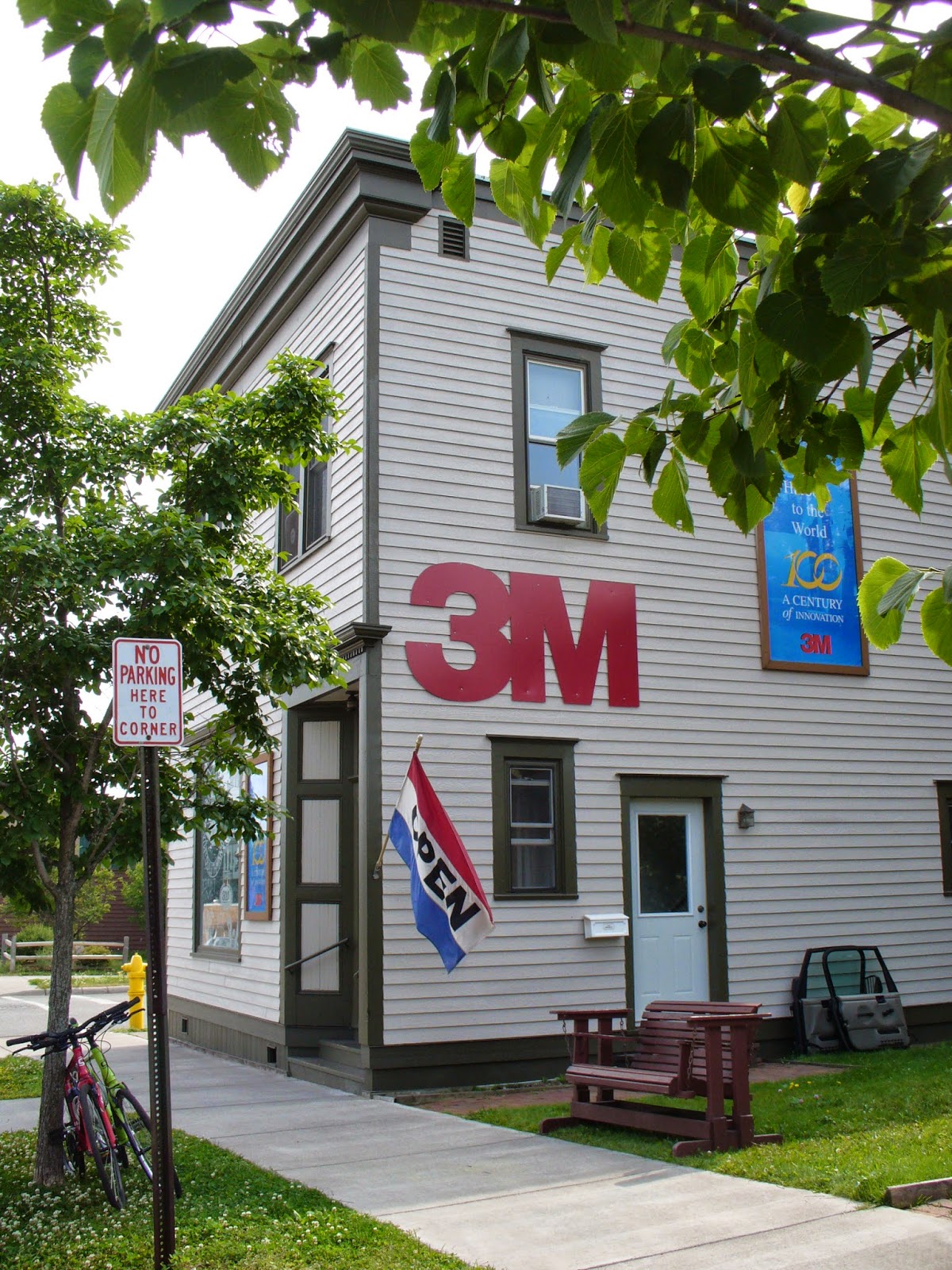
A tour of Two Harbors would not be complete without visiting the 3M Museum. The museum is located in the original 1902 office building where 3M had it's beginnings...exhibits within highlight the development of 3M products from sandpaper to scotch tape!
Tuesday, April 22, 2014
Total Lunar Eclipse
On April 15, 2014 there was a total lunar eclipse. As we were conveniently located at a RV park in northeastern Kansas, away from city lights, Kathy made plans to observe the event. Weather folks and meteorologists on TV predicted approximate viewing times for our area...before going to bed a look out the window showed a bright full moon and no clouds. Perfect!
Kathy set an alarm for the assigned event time, but managed to wake up before it sounded...through the motorhome front window she was able to watch as the moon passed through the Earth's shadow; the moon finally became completely in shadow, then the colors began...indirect sunlight, filtered and refracted by Earth's atmosphere caused the moon to flicker with a reddish-orange-gold hue. It was very neat to see!!
(Note: to our more scientific followers...hope this is an accurate explanation of how a total lunar eclipse occurs!)
Thursday, April 3, 2014
Organ Pipe Cactus National Monument
Organ Pipe Cactus National Monument is located south of Ajo, Arizona and extends to the border with Mexico. This section of the Sonoran Desert was established as a national park in 1937, primarily to preserve this environment from land use development. In 1976, this area was declared an International Biosphere Reserve site by the United Nations because of it's plant diversity; rare and endangered species; and delicate ecosystems. Sonoran pronghorn deer, a tiny fish called a pupfish, and the Sonoyta mud turtle are a few of the vanishing species who call this region home.
The Organ Pipe Cactus is common to Mexico, but is rarely found in the United States. In fact the National Monument site is one of the few places in the US where large stands of these cacti exist. The organ pipe cactus can live up to 150 years; it produces it's first flowers at age 35. The flowers blossom at night, so they can be pollinated by bats, then close by mid-morning the next day.
Two scenic drives on winding, graded dirt roads take you into the desert valleys and canyons. Hiking trails lead to the remains of historic ranch and mining sites. Campsites and picnic areas are also available.
Sunday, March 30, 2014
Tubac Presidio State Park
Final stop on our road trip south of Tucson on I-19 was the town of Tubac. Established in 1752 as a Spanish presidio (fort), the archeological remains of the fort are now a state park. One of the oldest European settlements in present day Arizona, the military fort was established to serve as a base for further exploration of the southwest and to protect colonists. The church established missions nearby. From this site in 1776 military leader Juan Bautista de Anza organized an expedition that resulted in the founding of present day San Francisco. The fort was abandoned and reestablished by the Spanish several times in history...it was deserted when the 49er's were lured to California to search for gold. During the Gadsen Purchase of 1853, Tubac again was resettled and developed by mining companies; the population grew. In 1859 the first newspaper was printed. But, during the Civil War the settlement failed again...eventually mining in the Tombstone area and railroads in Tucson pulled settlers from Tubac.
Today only the foundation of the original fort remains. An extensive museum contains artifacts and historical memorabilia from Tubac's past, including the printing press used to print the first newspaper. This historic village on the Santa Cruz River now attracts artists, writers, and history buffs...shoppers come to enjoy the arts, crafts, pottery, and jewelry found in small shops in present day Tubac.
Madera Canyon
While on a recent drive south of Tucson along I-19 we turned off to explore Madera Canyon. Madera Canyon is part of the Santa Rita Mountains, located within Coronado National Forest. One enters the canyon at the desert floor and reaches the peak turnabout at an elevation of slightly over 5000 feet. As one ascends,the scenery changes from cactus to pine trees! Picnic areas and hiking trails are common. There is even a Bed and Breakfast, and a few private homes located within the forest area.
One feature that caught our attention were what appeared to be "ghost trees". Located along a creek bed at one of the picnic areas were a number of these unusual trees...they were tall, the bark was smooth and white, and they had no leaves. From a park sign we learned they were sycamore trees...riparian, deciduous hardwoods that grow to 60-100 feet tall; found along river banks, creeks and streams; the smooth white bark is characteristic. These trees were just starting to form leaf buds in the early spring...
Titan Missile Museum
The Titan II missile is the largest missile built by the United States. During the Cold War period in the 1960's as many as 54 of these missiles were built and placed in underground silos (18 each near Wichita, Kansas, Little Rock, Arkansas, and Tucson, Arizona); missiles were active and ready to launch if state of war was declared. In 1982 Titan Missile sites were decommissioned and all operational silos were demolished, except one...located south of Tucson this site has been preserved as a National Historic Landmark. Public tours are now available.
We visited the site, starting out with a video presentation about the Titan Missile Program. After that we walked into the yard and descended 55 steps to the control room doors...massive amounts of steel and cement protected the control room. Walls at least 4 feet thick and 3-ton, 2 feet thick blast doors sealed various areas of the site from the surface. Huge springs and shock absorbers were built into the underground structures to help them withstand explosions from above ground. Along the way were three stations where persons entering the site would have stopped to call from a wall mounted phone and give their security information in order to proceed further into the tunnels.
Once in the control room we watched as our guide took us through the steps involved for a missile launch: Two-person teams worked together if the call to launch was received. It came in secret code; both persons took their key and opened the double locked file cabinet to remove the secret files used to interpret the code. The code told which of three pre-programed sites was the intended target. Once the target was chosen, again two keys were turned in separate areas of the control room and a red button flashed...at this point there was no turning back!
From the control room we walked through one cableway, or tunnel, to the silo where a Titan II Missile stands; no fuel remains in the rockets and the warhead is absent, allowing it to be safely displayed to visitors. Huge concrete doors above the silo are partially open, so from outside you can look down into the 150 foot deep silo. Also outside were various antenna towers for communication and motion detecting devices used for security.
During the tour one was reminded of how much technology changes...secret codes, double turn keys, locked file cabinets, computer programs on reels of tape, data hard drives the size of refrigerators...what a different time it was!
Saturday, March 22, 2014
Gallery in the Sun
Gallery in the Sun is a 10 acre historic landmark located in the foothills of the Santa Catalina Mountains near Tucson. The Gallery is a complex of hand-made buildings and structures designed and built by Arizona artist Ettore "Ted" DeGrazia. DeGrazia is well known for his paintings of native cultures of the Southwest, many of which are on display in the Gallery.
Also on the grounds is Mission in the Sun, built in 1952 of native adobe, and dedicated to Father Kino (early missionary) and Our Lady of Guadalupe (patron saint of Mexico). DeGrazia's original home and his gravesite are located near the mission church.
Likely most well known of DeGrazia's paintings is "Los Ninos", which was chosen in 1960 as the artwork for a UNICEF greeting card.
Sabino Canyon
We recently visited Sabino Canyon, located in the Coronado National Forest northeast of Tucson. The park features shuttle buses that provide narrated tours through the canyon. The buses follow about 4 miles of dirt road and cross 9 bridges on the way up into the Santa Catalina Mountains. The road and bridges were built by CCC workers during the 1930's. Along the way are 9 stops where one can depart the bus and enjoy hiking trails, picnic areas, and even swimming holes (but the water is pretty cold!).
Original inhabitants of this canyon area included the Hohokam Indians, who lived near the creek about 1200 AD and used the water to irrigate crops. Rocks along the creek still have indentations and holes worn in them, formed by grinding stones as grains were prepared for food. The swimming holes are known to have been used back in the 1870's by soldiers from nearby Fort Lowell. And today the canyon is popular with hikers of all abilities, as the trails are graded according to ease of climb and distance.
Sunday, February 23, 2014
Water Management
An assured supply of Water is one priority for those living in Arizona. On a recent field trip, we toured a pump station and learned about the Central Arizona Project (CAP), a project appropriated by federal and state authority to bring water from the Colorado River to Central Arizona.
Central Arizona obtains water from three sources: groundwater, runoff from surrounding watersheds, and the CAP. At first, groundwater use was mostly unregulated. As a result, this source was overused, which led to empty aquifers and fissures developing as the ground sank into the voids created. Since 1980, state regulations have managed groundwater use.
Surface water runoff is managed by Salt River Project, where runoff water and snow melt from nearby mountainous areas collects in the Salt River and Verde River. The river water is then captured in reservoirs behind a series of dams so the flow can be managed.
CAP delivers Colorado River water from Lake Havasu, on the state's western border, to Maricopa, Pinal, and Pima counties in Central Arizona through a 336 mile system of pumping stations, concrete-lined canals, and aqueducts. Computer controlled commands send signals to various parts of the system to regulate water flow. There is even a means to store excess water in underground "banks" for future use. In addition, CAP is working with other groups to develop alternative water supplies, including desalination of ocean water.
Awareness, management, and conservation will continue to play important roles in the future of Arizona's water sources.
MAC Farm Desert Ag-Ventures
We recently spent a day at the Maricopa Agricultural Center (MAC), a 2100 acre research and educational center operated by the University of Arizona. We watched videos and listened to lectures about desert agriculture, had a question & answer session with one of the faculty members, and toured a couple areas of the complex, including the cotton gin, vegetable garden, and siphon irrigation field.
MAC research focuses on plants currently grown in this area, including cotton, small grains, and alfalfa, plus potential new specialty crops for arid land including guayule, hesperaloe, jojoba, and lesquerella. Quayale is a desert native shrub which can be used for rubber production; it has less protein than natural rubber and makes a latex rubber that can better tolerated by persons with latex allergies. Hesperaloe is a long-lived perennial plant native to Mexico; it produces long thin fibers useful in paper production and is being studied as a new crop for the desert southwest. Jojoba is a native evergreen plant whose seeds contain a liquid wax used in cosmetics and for industries that require heat resistant lubricants. Lesquerella is being studied as a potential oilseed crop, similar to castor beans; it grows with very little water use.
The irrigation program at MAC deals with all facets of agricultural irrigation from water delivery to how crops use that water. The research acres have both ground water wells and irrigation canals, so they can replicate most any method used by local farmers. MAC maintains a weather station that records temperature, wind speed & direction, rainfall, etc. on an hourly basis, then stores that information for historical uses.
One researcher described how important GPS is to farming...from crop yield reports generated row-by-row as the farmer harvests a crop they can determine which parts of a field need more or less moisture, pesticides, or fertilizer. Sensors on equipment can then accurately deliver those based on the GPS locations of the areas identified. GPS also allows accurate planting and weed control...machines can get closer to the plants during cultivation to remove weeds, so less spraying is needed.
Besides entertaining "snowbirds", the facility hosts visitors and researchers from across the nation, and internationally.
Monday, February 10, 2014
December 2013 Day Trips
In December, we took several day trips while the kids were here to visit. One day was spent near Tucson, visiting the Arizona-Sonora Desert Museum. This site is a combination of botanical garden and zoo, featuring desert plants and animals in natural habitat settings. The hummingbird enclosure was fun, as the tiny birds buzzed by your head as they flew from flowers to feeders. If you were wearing red or pink, they would even stop momentarily and explore your clothing. Trails, surrounded by cacti and brush, led to enclosures of bobcats, coyotes, prairie dogs, javelins, desert tortoise, etc. The Earth Sciences Center had a limestone cave and hands-on mineral and meteor displays. An art gallery, aquarium, and restaurants are also part of the complex.
On the way to the Desert Museum, we drove through parts of Saguaro National Park. This park preserves some of the densest stands of giant saguaro cactus, a symbol of the desert southwest. These giant cacti can live up to 200 years; they reach heights of 50 feet, with arms reaching out in unusual configurations. They are slow growing plants, taking up to 15 years to grow a foot high, and up to 75 years to form their first "arm".
Another trip was to Rooster Cogburn's Ostrich Ranch just south of Casa Grande. An hour or so of fun was had by all, feeding and interacting with the animals on the ranch...including donkeys, deer, goats, ostrich, prairie dogs,and geese. Most exciting was the Rainbow Lorikeet Forest, an enclosure of noisy colorful birds, the lorikeet, These birds would fly to you and eat nectar out of the cups you were holding (even removing the lid from the cup if you hadn't already done so).
On the way to the airport in Phoenix, we spent a while walking in Papago Park and climbed up for a close view of landmark "Hole-in-the Rock". Hole in the Rock is a natural geological formation where the sandstone hill has been eroded to create a hole clear through the rock. It was a fairly easy climb on rough trails up the back side of the hill and into the hole. Historically the formation was likely an observatory used by early inhabitants to record positions of the sun during different seasons. Markings on surrounding rock correspond to seasonal solstices and equinoxes, creating a type of calendar system.
Thursday, January 30, 2014
Motorhome Stowaway
It was fall, 2013 and we were beginning to prepare the motorhome for our trip South. As Kathy opened the towel drawer in the bathroom, she found a surprise...there among the towels (now chewed and torn) was a cozy nest! In the drawer below was a stash of acorns...looked like someone besides us was planning for a long winter.
We set out to discourage the stowaway...nest and nuts were removed, repellents were added, and still more acorns kept appearing. In desperation we set out baited live traps, as by then we had determined the culprit was likely a little red squirrel seen disappearing under the motorhome on several occasions. Our efforts paid off...we eventually caught the squirrel and moved him to a local park with lots of oak trees. Then we continued our packing...
Subscribe to:
Posts (Atom)