Tuesday, August 22, 2017

Yakima Valley Washington


From the Willamette Valley in Oregon we headed north to spend a few days in the Yakima Valley, Washington.

Yakima Valley, settled between high desert grassland hills, includes towns such as Naches, Yakima, Union Gap, Toppenish, Zillah, Sunnyside, Grandview, & Prosser.

This fertile valley, enhanced by irrigation waters and abundant sunshine, produces fruits, vegetables, grapes, and 75% of the United States hop crop.


Acres of apple, pear, plum, & cherry trees, blueberry bushes, vineyards with varietal grapes that support local wineries, and hops that are shipped around the nation & used by local breweries...all grow here.

Wine tasting is popular, as is sampling craft beers.


Vegetables such as asparagus, tomatoes, corn, peppers, and melons supply abundant local produce stands, and retail grocery stores.

Thursday, August 17, 2017

McKenzie River Highway

Highway 126 as it heads east from Eugene, OR is known as the McKenzie Highway.  It follows the curves of the McKenzie River, passing grazing lands, fruit & nut orchards, and fishing hotspots. At the town of McKenzie Bridge, one turns onto hwy 242.  This scenic highway leads one into the Cascade Mountains on a steep, curvy climb to McKenzie Pass, 5324 ft elevation.  This section of highway into the Mt Washington Wilderness is generally closed from November until June because of heavy snow. And, it is always closed to trucks and large vehicles (like motorhomes!).  We did this trip by car with relatives from Eugene as tour guides.

 
At the top of the pass is Dee Wright Observatory, a lava-stone structure built in 1935 by the CCC.  Openings in the turrent-like building frame landmarks in the area, and identify nearby mountain peaks.  Belknap Crater (below), source of the huge lava field that covers the ground here, is visible, as is Mt. Washington, Mt. Jefferson, and Peaks of the Three Sisters mountains.

 
After lunch in the town of Sisters, we drove back on hwy 126, stopping to see Koosah Falls near the start of the McKenzie River. 

The gardens at Belknap Hot Springs Resort (where hot water bubbles from a crack in the rocks), and a pie shop in Vida were also on tour.

Sunday, August 13, 2017

Pacific Coast : Newport Oregon

Newport has two historic lighthouses: Yaquina Bay Lighthouse and Yaquina Head Lighthouse (pictured).

Yaquina Bay Lighthouse is the oldest building in Newport, built in 1871.  It is unusual in that the lighthouse and the keepers house are all one structure.  No longer in use, it is now a museum.

Yaquina Head Lighthouse, first illuminated in 1873, is the tallest along the Oregon coast. It took more than 370,000 bricks to build it. There is an interpretive center on site where we watched a film and read displays about the history of the lighthouse.  Tours of this active lighthouse are also available.

Newport's Bayfront & Harbor district are home to the US Coast Guard and one of the largest commercial fishing fleets in Oregon.  We had lunch at a bayside restaurant, then visited a fish market, and watched fish and crabs being unloaded from a fishing boat.    Other attractions include the Oregon Coast Aquarium, Hatfield Marine Science Center, Marine Discovery Tours, and the Pacific Maritime & Heritage Center.

Newport also marks the start (or end, depending on which direction you are traveling!) of Hwy 20, an east-west cross-country route that goes all the way to Boston, and may be the longest continuous highway in the US.


Wednesday, August 9, 2017

Sea Lion Caves

Eleven miles north of Florence, OR, on coastal highway 101 is a unique attraction: Sea Lion Caves.  Discovered in 1880 when a sea captain rowed a small boat through a fissure in the rocky shore, the caves contained hundreds of Steller sea lions.  Over the years  the cave has been kept as natural as possible, allowing the seals to maintain their winter home.  In spring and summer, they are found on the rocky ledges of shore line, with the young pups.  An elevator has been added, to allow visitors to descend 208 feet below and observe the sea lions in the cave...in their natural surroundings. 


From outside observation decks, you can see the sea lions along the shore. Other residents of this beach area are diving Cormorants, sea birds who dive for fish and tend their nests on the rocks.

You can also view Heceta Head Lighthouse.  This lighthouse stands 1000 ft above the water.  It sends one of the strongest signal lights along the coast.  The keeper's house is now a bed & breakfast.

Oregon USA

From British Columbia, Canada our next stop would be the state of Oregon, USA.  We entered Oregon by crossing the Columbia River at the Plymouth/Umatilla bridge, near Hermiston.  Picking up I-84 we followed the Columbia River westward. 

Along the way we started seeing glimpses of snow-topped Mt Hood...Oregon's highest peak at 11,239 ft.


Eventually we turned south on hwy 97, driving through the high desert on the east side of the Cascade Range.  "Back in Time" scenic highway 97 led us through small towns and grasslands.  Near Shaniko was a sign "you are at the 45th parallel:1/2 way between the equator and the north pole."

At Sisters, OR we turned west again, following hwy 20: "Over the River & Thru the Woods" scenic highway.  This road took us into the Cascades and over Santiam Pass (4800 ft elevation), then 11 miles of a 6% downgrade into the McKenzie River valley.  We drove by large moss covered trees, over hills & around lots of curves.

Sunday, July 30, 2017

Radium Hot Springs BC


Radium Hot Springs BC would be our last place to visit in Canada.  To get there we drove Hwy 93S through Kootenay National Park.  This park, designated in 1920, has a diverse geography, from glacier peaks to grasslands.  Part of the route had seen forest fire (in fact there was an active fire as we drove through, although we never saw flames; only the slight smell of smoke in the air).


Radium Hot Springs, the town, is located just outside the park boundary.  It has an alpine village feel, with restaurants serving Austrian, Bavarian and German style foods.  A wandering herd of bighorn sheep call the town home; we only saw one, but sometimes the entire herd is seen resting along the highway


And there are the hot spring pools located at the edge of town. From early settlers and travelers, to today's tourists, many have stopped to visit and soak in the mineral rich waters.   Other attractions are golf, whitewater rafting, hiking, and cross-country skiing in winter.


One day we toured the town of Invermere, just south of Radium.  Setttled on the shores of Lake Windermere, the little village hosts quaint shops and galleries, cafe's and coffeeshops. One could stroll around town, wade along the shores of the lake, or even rent kayaks or canoes...in winter, there is even ice fishing.

As we headed south toward the border, we drove through the Columbia Valley, where the Columbia River has it's beginnings in the wetlands around Canal Flats.

Tuesday, July 25, 2017

Banff National Park

Banff National Park, established in 1885, is the first national park designated in Canada.  The scenic resort town of Banff attracts millions of tourists annually, for summer scenery and winter skiing.

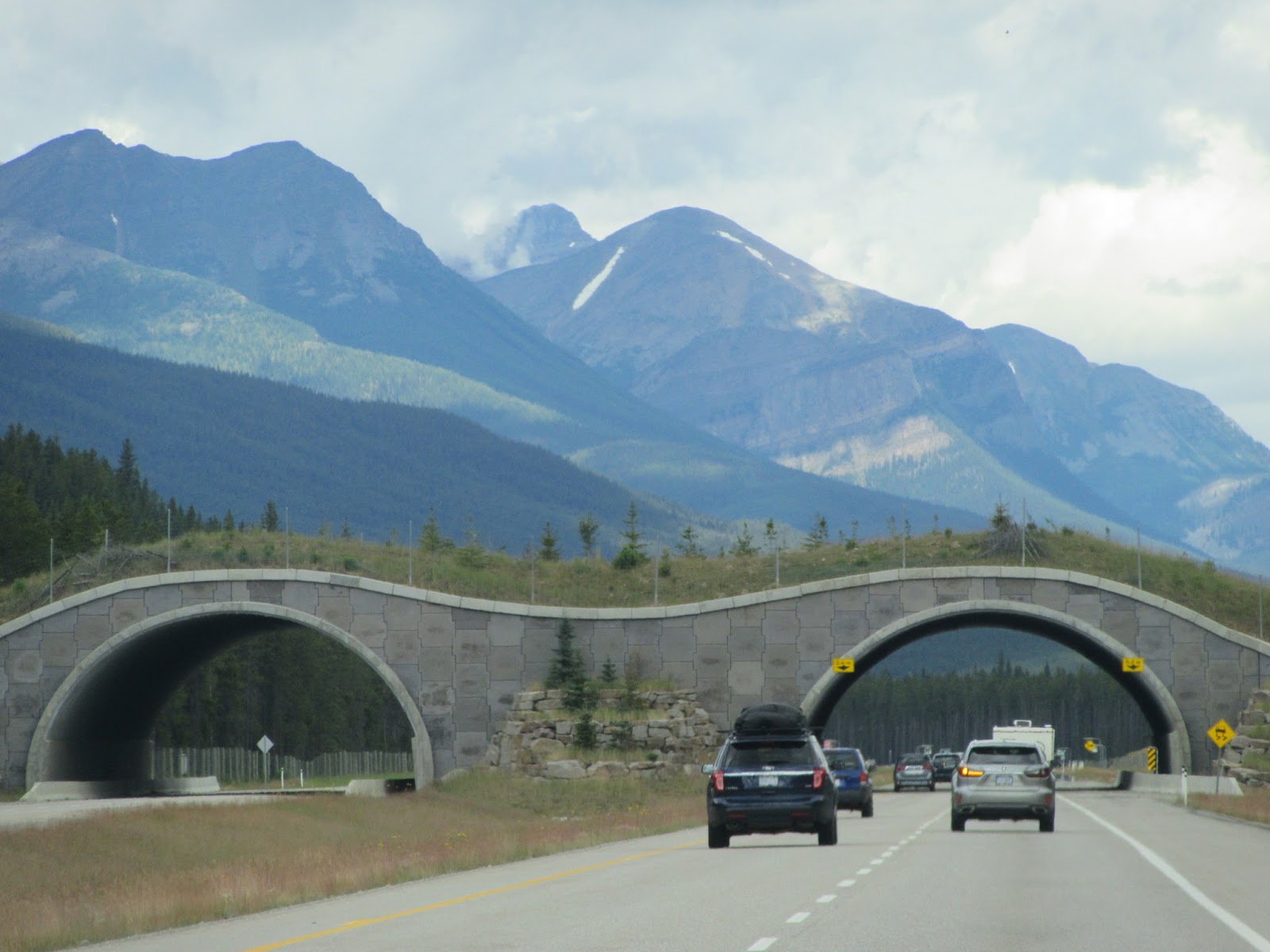
From Banff we drove north through the park on the Trans-Canada Hwy (Hwy 1) to Lake Louise. The highway has some unique overpasses designed to allow large animals to cross the highway without getting hit by vehicles.


Lake Louise/ Victoria Glacier (left) are one of the most photographed locations in the Canadian Rockies.

After lunch, we drove further north along the Icefields Parkway (hwy 93N).  This drive takes you through ancient glacier fields, dramatic rocky spires, and emerald-color lakes.

Bow Lake (right) was especially scenic. Just north of the lake we crossed Bow Summit, highest point on the Icefield Parkway (2088 m/6849 ft elevation).  Late afternoon we drove back to base camp near Cochrane, Alberta (just west of Calgary).

To celebrate "Canada 150" anniversary, the park service is giving free admission passes to all visitors in 2017.