Thursday, September 20, 2018

Door County Wisconsin


Door County, a finger-like peninsula of land between Green Bay & Lake Michigan, has a variety of things to see and do.


Harbors, boats, lighthouses, beaches, sheer sandstone bluffs, dense forests of tall trees, state and county parks, fields of corn, cherry and apple orchards, golf courses, wineries and craft breweries, dairy farms, and small towns packed with restaurants, markets, shops and galleries for all.  Biking, hiking, and kayaking are popular.


A couple traditional things to do while there are: attend a "fish boil"


look for the goats grazing on rooftops in Sister Bay,


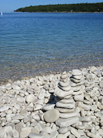
take a ferry to Washington Island to see the rocks at Schoolhouse Beach.


Sunday, August 5, 2018

Bailey Yard North Platte Nebraska

Located in North Platte, Nebraska,  Union Pacific's Bailey Yard (named after long time Union Pacific president Edd Bailey) is one of the largest railroad classification yards in the world.  The rail yard covers 2850 acres of land, is 8 miles in length, and contains about 315 tracks.   Nearly 10,000 train cars pass through daily.  
The classification "hump" yard uses a unique mound system to sort cars bound for different destinations.  Cars from one train are rolled onto the hump, disconnected, then allowed to roll gently down the mound to be directed and reconnected to the new destination train.  In addition to this classification or sorting activity, Bailey Yard repairs, maintains, and fuels hundreds of diesel engines daily.


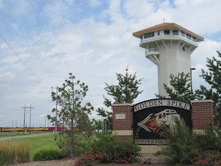
Bailey Yard activities are best seen from the Golden Spike Tower located nearby.  From observation decks 8 stories above the rail yard one can watch the trains come and go.  Guides (former Union Pacific employees) are present to answer questions or tell stories about working the yard.  Interactive kiosks and videos also offer information about the trains.

Scotts Bluff Nebraska

Along the North Platte River in western Nebraska a huge formation of sandstone and siltstone rises 800 feet above the prairie landscape. 

Scotts Bluff was a welcome sight in the 1800's as fur traders, military expeditions, pony express riders, and caravans of pioneers and settlers following the Oregon Trail headed westward.  Once they saw Scotts Bluff, they knew they were near Fort Mitchell, and that Fort Laramie, Wyoming wasn't far away. Weary emigrants in their covered wagons knew the western destinations of Utah, California, or Oregon were getting closer.  The relatively flat valley across the plains, and abundant water from the North Platte River, made this a favorable route to follow.


It is estimated that between 1841 and 1869 some 350,000 people joined wagon trains that traveled through this area of Nebraska.

Monday, July 9, 2018

Hannibal, Missouri

During our spring, 2018 travels, in May we spent a few days in the Hannibal, Missouri area.  We went first to Mark Twain Birthplace State Historic Site near Florida, MO.  The small two-room cabin birthplace of Samuel Langhorne Clemens (Mark Twain) in 1835 is now preserved inside a modern museum.  An assortment of artifacts from other aspects of Clemens life, as well as many photos and books, are located there.   In 1839 the Clemens family family moved to Hannibal, MO.  Samuel's childhood adventures along the Mighty Mississippi later served as the basis for his stories about Huckleberry Finn, Tom Sawyer, and others.  The authors pen name "Mark Twain" was first used in 1863.  In Hannibal, several historic properties related to Mark Twain are preserved and open as a self guided tour.  All attractions are included in one ticket price.  The Main Street Museum included 15 original Norman Rockwell paintings, as Rockwell was illustrator for some of  Twain's novels. 
Moored along the Mississippi River was Mark Twain Riverboat, which offers cruises with narrative commentary on river history, etc of the Hannibal area (Clemens had been a riverboat pilot himself, piloting on the Mississippi River for about 4 years prior to the start of the Civil War.
(I liked this painting located in the Hannibal Museum, so will use it as my photo this time)

Monday, April 30, 2018

Rio Grande Gorge Bridge


About 10 miles northwest of Taos, New Mexico on US highway 64,  this 1280 foot long steel deck arch bridge spans the Rio Grande Gorge.  At 565 feet above the river, the gorge bridge is one of the highest in the US highway system.  It was built in 1963-1965.


Canyon de Chelly Arizona


Canyon de Chelly National Monument was established in 1931.  Embracing nearly 84,000 acres within the Navajo Reservation in north-eastern Arizona, these canyons on the Colorado Plateau have been inhabited for nearly 5000 years.

The Navajo entered the canyons about 400 years ago. They brought sheep and goats, planted corn and fruit trees, and lived mainly on the canyon floor. Some Navajo farmers continue that tradition today.

From the visitor center near Chinle, perimeter rim drives with many overlooks allow visitors to get a panoramic view of Canyon de Chelly.  Each drive is about 35 miles round trip by car.  Near the visitor center canyon walls are not so steep, and the canyon floor is open.  This is where many of the farms are.  At the end of South Rim stands Spider Rock, an 800 ft tall sandstone spire reaching up from the canyon floor (photo above).

Remains of cliff dwellings dot the canyon walls; dramatic rock formations jut out from every corner; cropland and grazing animals dot the canyon floor.  Horseback and jeep tours of the canyon floor are available with local guides.  Short hikes allow access to a couple of the larger cliff dwelling sites.